
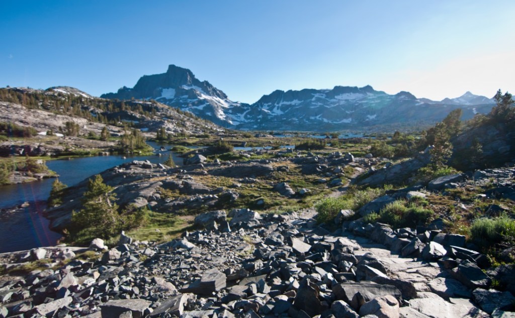
The San Joaquin at 400 miles is California’s second longest river. Born of Sierra Nevada Mountain snowmelt some 9800 feet above sea level, it flows southwesterly to the floor of the Central Valley and then hooks northwesterly towards its destination at the Delta of San Francisco. The mountain snowmelt that mothers the San Joaquin and its tributaries is pretty much all the water that sustains it (or used to sustain it prior to the era of diversions), as the Central Valley desert receives well less than a dozen inches of rain per year.

In the mountains, the San Joaquin flows steeply and mostly freely down-mountain in the beauty that is the Sierra Nevada. There, the stream supports trout and allied coldwater species, while the surrounding land is inhabited by black bear, mountain lion, mule deer, gray squirrel, golden-mantled ground squirrel, and various migratory and resident birds. We should not neglect also hikers, backpackers, kayakers, and fisher-folk.
But as it descends into the foothills and Valley, the River gets dammed, dried, rewetted, diverted, used, and some would say, abused.
On this late June day, we five (my University colleague and three magnificent staffers from the US Bureau of Reclamation) are at the Friant Dam and its Millerton Lake reservoir in the foothills. Though the river has only flowed a quarter of its 400 mile journey, already it’s descended over 9000 feet, leaving 500 more to go.
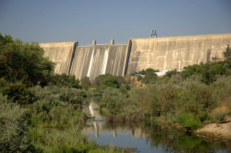
At Friant Dam, we meet with Mike the dam operator, a jovial and helpful fellow who is very kind to his two Midwestern guests. He seems to be the kind of guy who would help you fix a flat tire and then apologize that he didn’t get there sooner.

The dam and its diversionary infrastructure are arguably the most course-changing piece of plumbing on the San Joaquin River. It was built as part of the Central Valley Project, a public works endeavor constructed largely to rescue irrigators who had exhausted their groundwater, according to Reisner’s Cadillac Desert. Built in 1937-42 and operationalized in 1944, the dam blocks prime salmon spawning habitat further up into the mountains. Not that it matters, as the dam was designed to entirely dry some 150 miles of river!
On the day we are at Friant Dam, the natural flow of some 3000 cubic feet per second descends from the mountains and enters the Millerton Lake impoundment behind the dam. Picture the average flow of the Wisconsin River at Stevens Point. That 3000 cfs is divvied up with 700 cfs going north in the Madera irrigation canal, 1800 cfs going into the Frian-Kern irrigation canal, and leaving just 293 cfs to go into the San Joaquin proper.

If you tracked the math, you noticed that less than 10% of the river’s natural flow continues down the river. Picture the trickle that would flow from Wisconsin at Stevens Point if it were reduced by 90%. But even this meager allotment is an illusion. Remember that the dam was designed to divert the entire river flow elsewhere? You might imagine that the irrigators downstream of Friant who depended on San Joaquin water might complain – and they did. Their complaints are what lead to some flow passage past the dam. Another but – even this is used up entirely over the next 30 miles, leaving the river dry for the next 60. Picture the Wisconsin flowing 10% of its natural amount from Stevens Point to Nekoosa, but then being dry through the through Petenwell Flowage, Castle Rock Flowage, and Portage.
No more Dells Ducks!

Back at the Dam, Mike remembers how tough recent drought years have been, and how there was no water at times to send to irrigators. He comments on how so far this year, so good: water supplies have been good. But then he pensively looks at the snowpack remaining in the mountains and wonders what the rest of the summer will bring.

great writing…….enjoy your perspective George as I always learn something new. Thanks!
LikeLike